
Complementary to IMU and GNSS Systems
+
Acts as a robust supplement to IMU and GNSS-based positioning systems, compensating for GNSS signal loss and IMU drift, particularly in GPS-denied or obstructed environments.
Correlates with AI-Driven Physical Ray Tracing Models
+
Utilizes high-accuracy AI-powered physical ray tracing to refine location estimates and predict signal behaviors in complex environments.
A-SLAM Assisted Mapping of Uncooperative Networks
+
Assisted SLAM combines AI-driven RF propagation modeling with real-world signal data to generate precise mapping of uncooperative or unknown cellular networks.
Supports Sub-Meter Accuracy with SDR
+
Achieves sub-meter accuracy by utilizing Software Defined Radio (SDR) technology implementing RF-enhanced TDOA and phase-based techniques.
Low-Cost Configuration for LoT Implementations
+

Designed to support scalable and cost-efficient integration into LoT devices and networks without compromising on performance.
Next-Generation Positioning

Mission Planning, Redefined
All the Capabilities of Atsmus Air, plus:
Mission Planning Optimization
+

Enhances UAV and autonomous vehicle missions by intelligently planning routes based on mission preferences, ensuring maximum efficiency, safety, and reliability.
3D RF Coverage Mapping
+
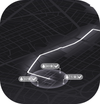
Generates detailed 3D coverage maps to visualize cellular connectivity at various altitudes and locations. Identifies zones with strong or weak coverage to maintain uninterrupted navigation control.
Accuracy Enhancement
+
Leverages cutting-edge 3D ray tracing propagation techniques to enhance the reliability and precision of TDOA and phase-based positioning systems.
